


At ACENTAURI-INRIA, we have many robots for different research projects used by Researchers, Engineers, Ph.D. students, and Postdocs.
For AgrifoodTEF, at the moment we have two types of Unmanned Aerial Vehicles (UAVs) i.e. DJI's Matrice 300 RTK (shared with other projects), DJI's Matrice 400 RTK (coming soon), Skydrone's VERSATYL (dedicated).
DJI Matrice 300 RTK
The DJI Matrice 300 RTK is a platform inspired by modern aviation systems. Offering up to 55 minutes of flight time, advanced AI capabilities, 6-way sensing and positioning and more, the Matrice 300 RTK sets a whole new standard, combining high-performance intelligence and unrivalled reliability.

In the framework of AgrifoodTEF, this robot is being used for:
- Data acquisition and Geolocalisation
- Ground truth for testing and evaluation of AI and Robotic Algorithms
- Autonomous navigation

Specifications
- Teleoperation: Bluetooth 5.1 (Range 10 meter)
- Teleconnection: ~ 1km
- Cameras
- Intel Realsense D457
RGB: 1MP, 1280×800 (30 fps), Depth: 1280×720 (90 fps, Stereoscopic), Range: 0.6 to 6 m - Intel RealSense D435f
RGB: 2MP, 1920×1080 (30 fps), Depth: 1280×720 (90 fps, Stereoscopic), Range: 0.3 to 3 m
- Intel Realsense D457
- LiDAR
- RoboSense RS-HELIOS 1615
Beams: 16, Wavelength: 95 nm, Range: 150 m, Precision: 1 cm, FoV (Vertical: 360°, Horizontal: -15° to +15°)
- RoboSense RS-HELIOS 1615
- GPS-RTK
- Ublox ZED-F9P (Receiver)
Type: Multiband GNNS high precision, Accuracy RMS: 30 ns, Frequency: 0.25 Hz to 10M Hz, Velocity Accuracy: 500m/s, Acquisition Time: 2s, Navigation Update Rate: 7 Hz (Max)
- Ublox ZED-F9P (Receiver)
- IMU
- VectorNav VN-100T-CR
Gyro in-run Bias: 5°/Hr, Accelerometer Range: ±16 g, Gyroscope Range: ±2000/sec, EKF Update Rate: 400 Hz, IMU Data: 800 Hz, Pitch/Roll: 0.5°, Accelerometer in-run Bias: <0.04 mg
- VectorNav VN-100T-CR


Usage in Facilities
- Mobile Living Laboratory
- UAV Arena
- AzurArena Parking
- Private Parking
Usage in Services
- S00209 General Purpose Datasets via Multisensored Ground Robot
- S00210 General purpose datasets via Multisensored aerial robot
- S00211 General Purpose Datasets with user specified sensor(s)
- S00212 Testing and Evaluation of Mobility Algorithms for Ground Robot
- S00213 Testing and Evaluation of Mobility Algorithms for an Aerial Robot
This is a movable equipment, cofunded by AgrifoodTEF
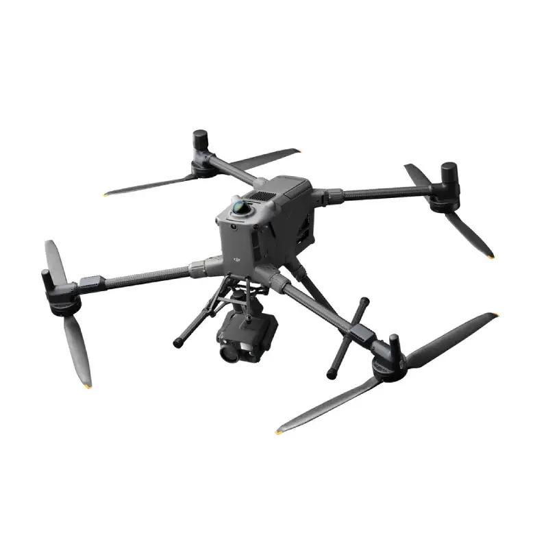
DJI Matrice 400 RTK
The DJI Matrice 400 RTK is the next-generation heavy-lift multirotor UAV and enterprise flagship from DJI. It offers up to 59 minutes of flight time, a payload capacity of up to 6 kg, and an advanced obstacle sensing system. The platform has been acquired by the team and is currently undergoing operational qualification.
In the framework of AgrifoodTEF, this UAV will be used for:
- High-resolution RGB and multispectral mapping
- LiDAR-based 3D point cloud acquisition
- Thermal and multispectral data collection for crop monitoring
- Ground truth for testing and evaluation of AI and Robotic Algorithms
Platform Specifications
- Type: Heavy-lift multirotor UAV
- Max flight time: 59 min (forward flight) / 53 min (hover)
- Max payload: 6 kg — up to 7 simultaneous payloads
- Positioning: RTK GNSS — RTK fix: 1 cm + 1 ppm (H) / 1.5 cm + 1 ppm (V)
- IP rating: IP55
- Operating temp.: −20 °C to +50 °C
- Status: Acquired — pending operational qualification
Payloads & Sensors
Zenmuse P1 — Full-Frame RGB Mapping Camera
The Zenmuse P1 integrates a full-frame 45 MP sensor with a mechanical shutter and interchangeable fixed-focus lenses, delivering exceptional photogrammetry results with centimetric absolute accuracy.
- Sensor: 35.9 × 24 mm full-frame CMOS — 45 MP — pixel size 4.4 µm
- Photo resolution: 8192 × 5460 (3:2)
- Compatible lenses: 24 mm (FOV 84°), 35 mm (FOV 63.5°), 50 mm (FOV 46.8°)
- Shutter: Mechanical 1/2000 s – 1 s / Electronic 1/8000 s – 1 s
- Absolute accuracy: Horizontal 3 cm / Vertical 5 cm (at 3 cm GSD, 75%/55% overlap)
- Gimbal: 3-axis stabilised — ±0.01° angular vibration
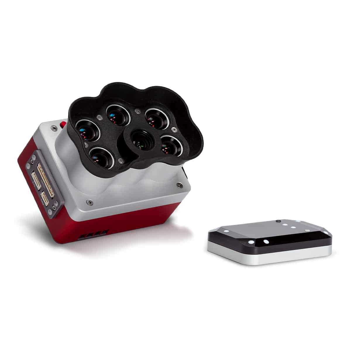
Zenmuse L3 — LiDAR + RGB Mapping
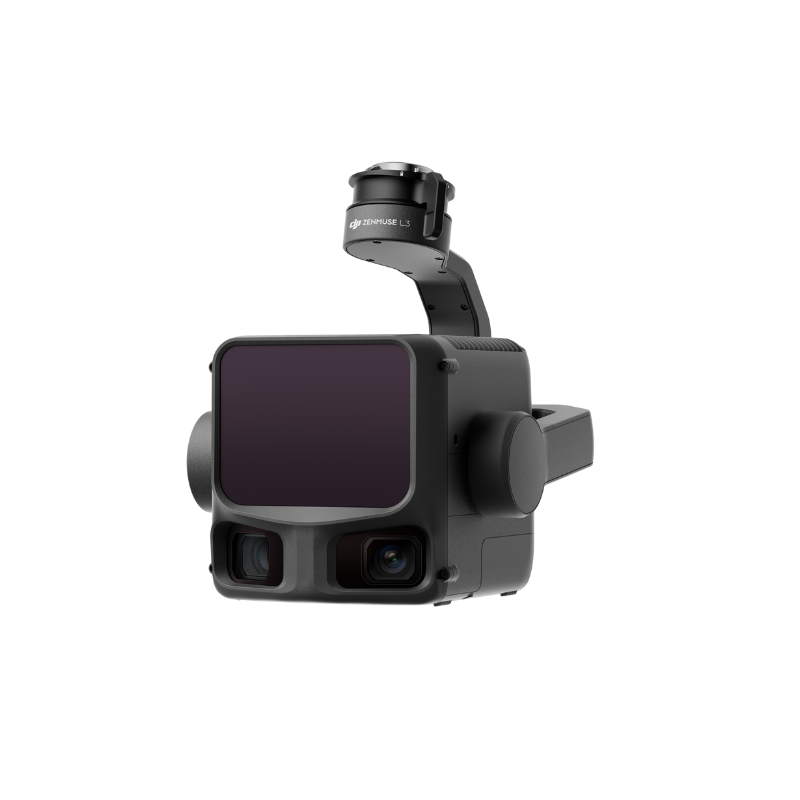
The Zenmuse L3 combines a high-precision LiDAR module with a dual 100 MP RGB camera system, enabling simultaneous point cloud and visual data acquisition from a single payload.
- LiDAR wavelength: 1535 nm — Class 1 laser (IEC 60825-1:2014)
- Point cloud accuracy @ 120 m: Vertical 3 cm RMSE / Horizontal 4 cm RMSE
- Point cloud accuracy @ 300 m: Vertical 5 cm RMSE / Horizontal 7.5 cm RMSE
- Detection range: up to 2000 m (80% reflectivity, 100 kHz)
- Scan modes: Linear (80° H × 3° V), Star (80° H × 80° V), Non-repetitive (80° H × 80° V)
- RGB camera: Dual 4/3″ CMOS — 100 MP (12288 × 8192) — combined FOV 107° H
- RGB GSD: ~3 cm average @ 300 m nadir
- Position accuracy (RTK fix): H: 1.0 cm + 1 ppm / V: 1.5 cm + 1 ppm
MicaSense Altum-PT — Multispectral + Thermal
The MicaSense Altum-PT captures simultaneous multispectral, panchromatic, and thermal (LWIR) imagery in a single flight, ideal for crop health monitoring and stress detection.
- Multispectral bands (5): Blue 475 nm, Green 560 nm, Red 668 nm, Red Edge 717 nm, NIR 842 nm
- Panchromatic: 634.5 nm centre — 12 MP (4112 × 3008 px)
- Thermal (LWIR): 10.5 µm centre — 320 × 256 px — sensitivity <60 mK — accuracy ±5 K
- GSD @ 120 m: 5.28 cm/px (MS) / 2.49 cm/px (Panchro) / 33.5 cm/px (Thermal)
- GSD @ 60 m: 2.64 cm/px (MS) / 1.24 cm/px (Panchro) / 16.75 cm/px (Thermal)
MicaSense RedEdge-P — Multispectral
The MicaSense RedEdge-P is a compact multispectral camera delivering five spectral bands plus a high-resolution panchromatic channel, optimised for vegetation index computation (NDVI, NDRE, etc.).
- Spectral bands (5): Blue 475 nm, Green 560 nm, Red 668 nm, Red Edge 717 nm, NIR 842 nm
- Panchromatic: 634.5 nm centre — 5.1 MP (2464 × 2056 px)
- Multispectral resolution: 1456 × 1088 px (1.58 MP/band)
- GSD @ 120 m: 7.7 cm/px (MS) / 3.98 cm/px (Panchro)
- GSD @ 60 m: 3.85 cm/px (MS) / 1.99 cm/px (Panchro)
- Output bit depth: 12-bit
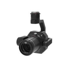
H30T — Multi-sensor Pod
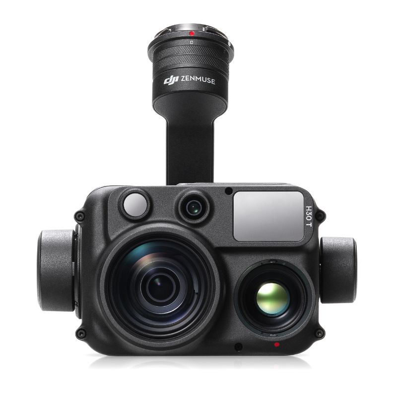
The DJI H30T is an all-weather multi-sensor pod compatible with the Matrice 400, integrating a wide-angle camera, zoom camera, infrared thermal camera, and laser rangefinder in a single compact payload.
Usage in Facilities
- Mobile Living Laboratory
- UAV Arena
- AzurArena Parking
- Private Parking
Usage in Services
- S00209 General Purpose Datasets via Multisensored Ground Robot
- S00210 General purpose datasets via Multisensored aerial robot
- S00211 General Purpose Datasets with user specified sensor(s)
- S00213 Testing and Evaluation of Mobility Algorithms for an Aerial Robot
This is a movable equipment, cofunded by AgrifoodTEF